Elevation Profile Viewer: See the Height of the Ground Along Any Route
What an Elevation Profile Shows
A normal map shows the land from above, so a steep climb and a flat road look the same. An elevation profile turns the route on its side: distance runs from left to right and height runs from bottom to top. Every hill becomes a rise in the line, every valley a dip. With one look you can see how much climbing a route needs, where the steep parts are and how high the highest point is.
What This Elevation Profile Tool Does
You place up to 5 points on the map. The tool joins them in order, asks an elevation service for the height of each point in one request, and turns the answers into a chart and a set of figures. Only your points are read: between two points the chart draws a straight line. To show a hill, a pass or a valley in the profile, put a point on it. The tool works anywhere between 60° north and 56° south, from a city street to a mountain range.
Free, With No Sign-Up
There is no account, email or payment. The points are sent only to read the elevation, the chart is drawn in your browser, and the PDF is made on your own device. Share links hold nothing more than the coordinates of your points and your display settings.
How to Use the Elevation Profile Viewer
Placing, Moving and Removing Points
Start by finding the area. Use the search box for a town, an address or a mountain, press My location, or pan and zoom by hand. Then click the map: the first click places A, the next B, and so on up to E. Each point gets its own colour, and a green line joins them in order. When there are two points the profile appears. Because the height is read only at your points, place them where the ground changes: the start, the tops, the low points and the end.
To move a point, drag its pin; the line follows while you drag and the profile is read again when you let go. To remove one point, press the small x on its chip under the map; the remaining points keep their order and are lettered again. Undo last point removes the newest point, Reverse route swaps the start and the end, and Clear all starts again. After five points, a click on the map does nothing until you remove one.
Map Styles and Units
The Street map is best for towns and roads, Satellite shows the real ground, trees and buildings, and Terrain adds hill shading and contour-style colours that make valleys and ridges easy to see. The m / km and ft / mi buttons switch every number, the chart and the PDF between metric and imperial units.
Reading the Summary and the Figures
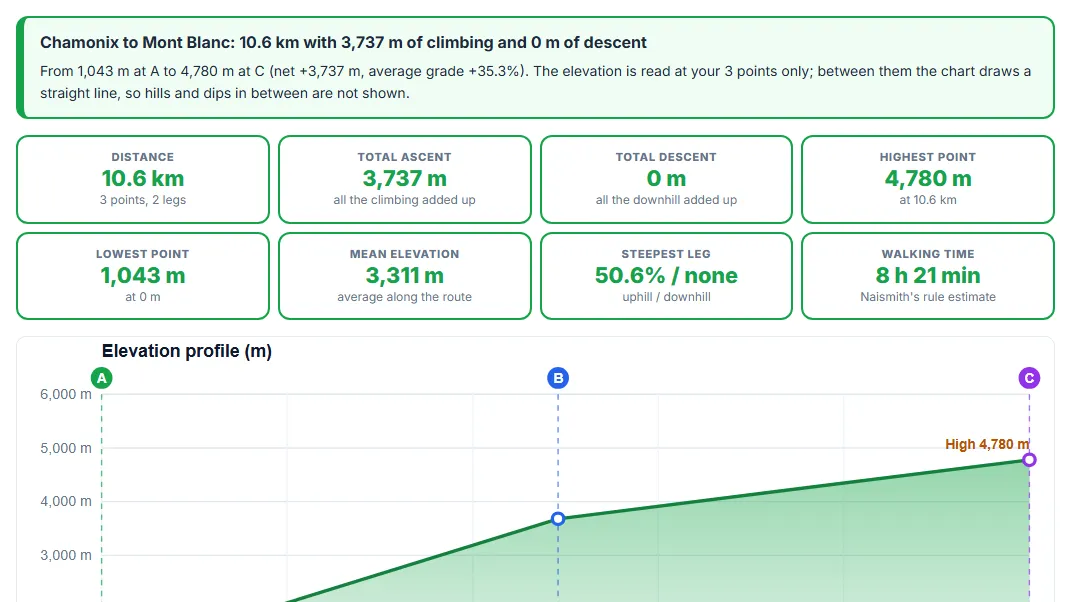
The green summary box gives the route length with its total climbing and descent, then the height at the start and the end, the net change and the average grade. The eight cards give the key figures: distance, total ascent, total descent, highest point, lowest point, mean elevation, the steepest uphill and downhill leg, and a walking time. Ascent and descent count the changes from point to point, so a climb between two points that is not marked by a point is not included.
Using the Interactive Chart
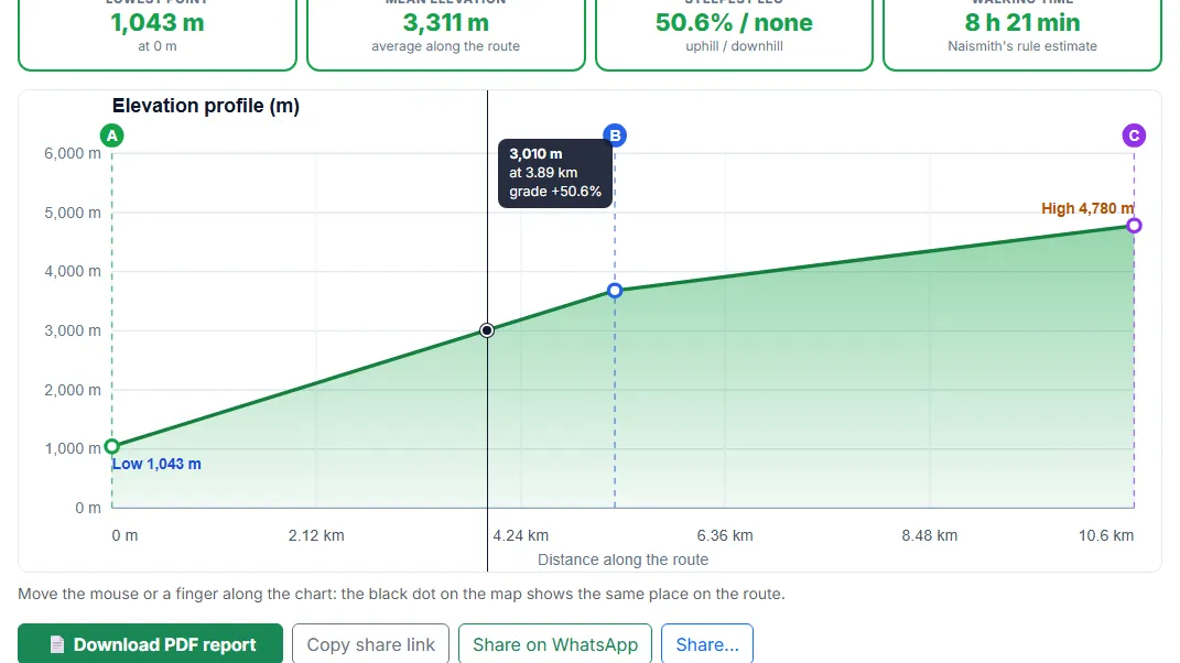
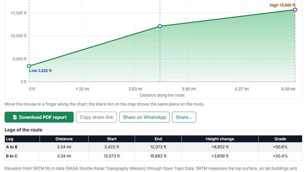
The chart plots the height of your points against the distance from A and joins them with straight lines. Coloured dashed lines and lettered circles mark the points, and the highest and lowest are labelled. Move the mouse over the chart, or slide a finger on a phone, and a tooltip shows the height on the line, the distance and the grade of that leg; close to a point it also shows the point’s letter. At the same time a black dot moves along the route on the map, so you can link any bump in the chart to a real place.
The Legs Table
Each pair of neighbouring points is a leg: A to B, B to C and so on. The table gives each leg’s distance, its height at the start and the end, the height change and the grade. This helps when a route has one hard section and several easy ones.
How to Make an Elevation Profile: Step by Step
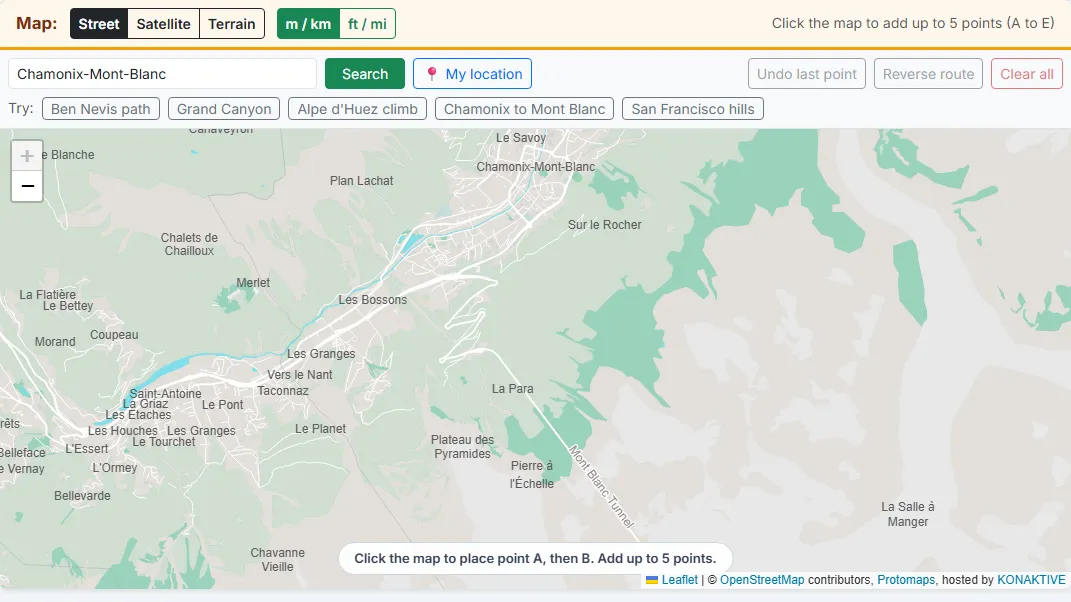
Type a town, an address or a mountain in the search box and press Search, or press My location. You can also drag and zoom the map by hand, or press one of the Try buttons to load a ready-made route such as the Ben Nevis path or the Grand Canyon.
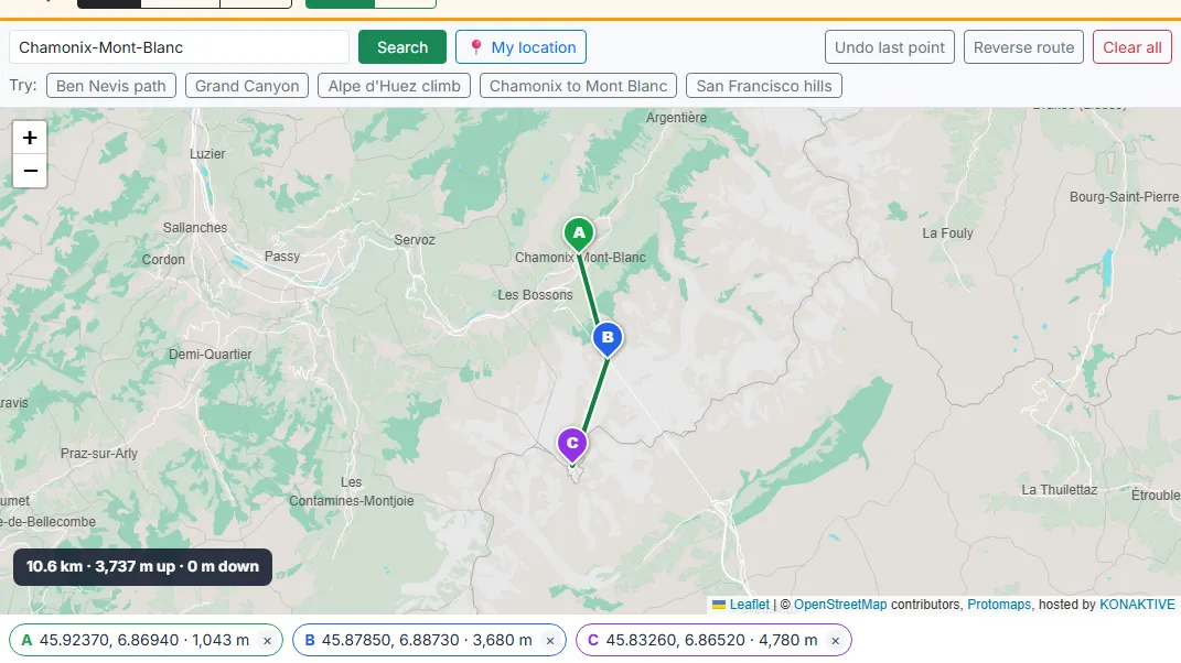
Each click adds the next lettered point, and a green line joins them in order. After the second point the tool reads the elevation of your points and draws the profile. Put a point on each hilltop or valley floor you want in the chart. Drag any pin to move it; the profile updates when you let go. Use the small x on a point, Undo last point or Clear all to change the route.
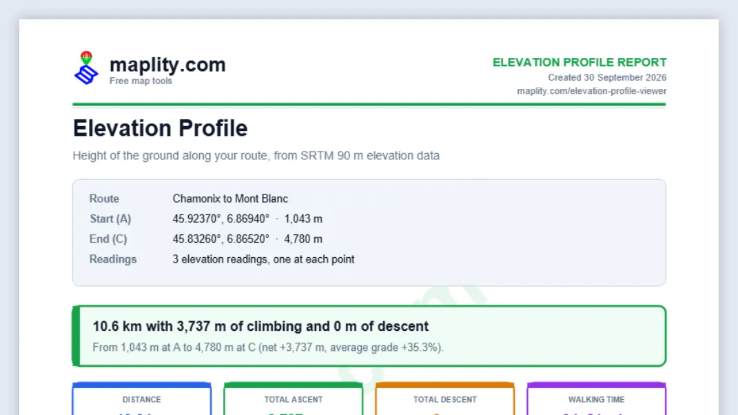
The green box gives the length of the route with its total climbing and descent, the start and end height and the average grade. The cards below show the distance, total ascent, total descent, highest, lowest and mean elevation, the steepest uphill and downhill leg, and an estimated walking time.
Move the mouse, or a finger, along the chart. A tooltip shows the elevation, the distance from A and the grade at that spot, and a black dot moves along the route on the map at the same time. Dashed lines mark your points, and the highest and lowest points are labelled.
The Legs of the route table splits the route at your points: A to B, B to C and so on. For each leg it shows the distance, the start and end height, the height change and the grade. Switch between m / km and ft / mi at the top of the tool.
Press Copy share link to copy a link that opens the same points, units and map style. Share on WhatsApp sends it with a short summary, and Share... uses your phone’s share menu. Download PDF report saves a report with the maplity.com letterhead, the chart and all tables.
10 Use Cases of an Elevation Profile Viewer
People in many fields need to know how the height of the land changes along a line. These are the most common.
1. Hiking and trekking
Before a day in the hills, place points at the car park, the main junctions and the summit. The total ascent and the walking time from Naismith’s rule tell you whether the walk fits into the daylight you have, and the chart shows where the steep section begins, so you can plan a rest before it.
2. Road cycling and mountain biking
Cyclists judge a climb by its length and its average and maximum grade. Put a point at the foot and the top of a pass, and the tool gives both, with the steepest part marked on the chart. It is a quick way to compare two ways over the same hills.
3. Trail running and race planning
Race organisers publish an elevation profile with the course, and runners study it to plan their pace. With up to five points you can rebuild the rough shape of a course, see where the long climbs and fast descents are, and share the link with your club.
4. Roads, rail and civil engineering
At the early planning stage, engineers compare corridors for a new road, railway or path. A profile along each option shows the highest point, the steepest grade and the overall rise, which helps rule out routes that would need too much cutting, filling or tunnelling.
5. Pipelines, canals and water supply
Water flows downhill, so gravity-fed pipes, irrigation channels and drains depend on a steady fall. Put A at the source, E at the outlet and the points in between on any rise along the line: the profile shows whether the ground falls all the way, or where a high point would need a pump.
6. Radio links and line of sight
Microwave, radio and Wi-Fi links need a clear line between two masts. Put A and E on the two sites and the points in between on the hills or ridges along the line: the profile shows whether any of them rises above the straight line between the masts. Over long links you also have to allow for the curve of the Earth, which the maths section below explains.
7. Property, building sites and flood risk
Buyers and builders can check how a plot sits against a nearby river or the coast. A short profile from the water to the building shows how many metres higher it stands, and whether the land slopes towards it or away from it.
8. Geography and geology teaching
A profile is a standard way to teach landforms. Students can draw one across a volcano, a glacial valley, a river terrace or a coastal cliff and compare the shapes. The famous-place tables below give ready-made examples from Europe and the USA.
9. Drones and paragliding
Drone pilots must keep a set height above the ground, and the ground is not flat. A profile with points on the high ground along the planned flight line shows where the terrain rises, so the flight can be planned to stay clear. Paraglider pilots use profiles to judge glide lines from a launch to a landing field.
10. Travel, driving and electric vehicles
Mountain roads, heavy vehicles and electric cars are all affected by long climbs. A profile of a pass shows how much height the vehicle must gain and lose, which helps with fuel or battery planning and with choosing a route for a caravan or a truck.
The 10 Most Useful Things to Check With This Tool
Whatever your reason for using it, these are the checks that save the most time and trouble.
- Check the total climb before you commit to a route. Total ascent, not distance, is what makes a walk or ride hard. Compare it with what you have done before.
- Find the steepest leg. The Steepest leg card and the legs table show which pair of points has the highest grade. Move a point to the top or the foot of the climb to measure it more closely.
- Compare two routes to the same place. Build the first route, copy its share link, then build the second. Put the two PDF reports side by side.
- Estimate the walking time. The Naismith figure is a fair starting point for fit walkers. Add time for breaks, bad weather and descents on rough ground.
- Check that water will flow the way you need. Place points along the line of a drain, pipe or ditch, on any rise you can see. The profile should fall from each point to the next, with no high point in between.
- See if a hill blocks the view or the signal. Place A and the last point on the two high points and the points in between on the hills along the line. If any middle point rises above the straight line from the first to the last, the view or the radio link is blocked.
- Measure how high a house stands above a river. Place A at the water’s edge and B at the building. The height difference is a first check of flood safety, not a replacement for official flood maps.
- Find the highest and lowest point of a trip. The chart labels both, and the cards give their height and distance from the start. This is useful for weather, snow and altitude planning.
- Teach or learn the shape of the land. Draw across a valley, a volcano or a coastline and describe what the chart shows. The share link makes it easy to hand the same profile to a whole class.
- Keep a record in a report. The PDF holds the chart, the points, the legs and the method, with the link to open the route again. It is handy for trip plans, site files and permits.
The Mathematics Behind the Elevation Profile
1. Distance Between Points: the Haversine Formula
The Earth is close to a sphere, so the distance between two points is measured along a great circle, the shortest path over the surface. The tool uses the haversine formula with a mean Earth radius R of 6,371 km:
d = 2R · atan2(√a, √(1 - a))
φ = latitude, λ = longitude, in radians
The route length is the sum of the leg lengths A to B, B to C and so on.
2. Joining the Points: Straight Lines Between Readings
Only the points you place are read, in a single request: a route with five points asks for five heights. The chart puts each point at its distance from A and joins neighbouring points with a straight line. When you hover between two points, the tool finds the matching place on the map along the great circle between them, and the height on the straight line of the chart:
height on the line: h(t) = h_A + (h_B - h_A) · t
place on the map: P(t) = [sin((1 - t)δ) · A + sin(tδ) · B] / sin δ, δ = angular length of the leg
The straight line is not the real ground. A hill or a valley between two points does not appear unless you put a point on it, which is why the tool is best used with points on the start, the main tops, the low points and the end.
3. Reading the Height of Each Point
SRTM stores one height for each cell of a grid about 90 m wide. A point usually falls between four cell centres, so the elevation service mixes the four heights by bilinear interpolation, giving a smooth value instead of a staircase:
x, y = position inside the cell, from 0 to 1
4. Ascent, Descent and Grade
For every pair of neighbouring readings, the rise is Δh = h(i+1) - h(i) and the horizontal distance is Δd. Positive rises are added to the total ascent and negative ones to the total descent. The grade is the rise over the run, and the slope angle comes from the arctangent:
grade (%) = Δh / Δd × 100 angle = atan(Δh / Δd)
average grade of the route = (h_end - h_start) / route length × 100
Example: three readings 100 m apart at 200 m, 212 m and 205 m give an ascent of 12 m, a descent of 7 m, grades of +12% and -7%, and an average grade of (205 - 200) / 200 × 100 = +2.5%.
5. Highest, Lowest and Mean Elevation
The highest and lowest points are simply the largest and smallest readings. The mean elevation is weighted by distance using the trapezoid rule, so a long flat stretch counts for more than a short one:
6. Walking Time: Naismith's Rule
The walking time uses Naismith’s rule from 1892, still the standard first estimate for hill walkers: 5 km per hour on the flat, plus one hour for every 600 m of ascent. A 12 km walk with 900 m of climbing works out as 12 / 5 + 900 / 600 = 2.4 + 1.5 = 3.9 hours.
7. The Curve of the Earth and Line of Sight
The chart plots height above sea level along the ground, so the Earth’s curve is not drawn. For a line-of-sight check between two distant points, remember that the surface drops away below a straight line. The drop at distance d is about d² / (2R): about 8 m at 10 km, 31 m at 20 km and 196 m at 50 km. Radio engineers often use an effective radius of 4/3 R to allow for the bending of radio waves in the air.
Data Sources and Libraries Used in This Tool
Elevation Data: SRTM 90 m
The heights come from the Shuttle Radar Topography Mission (SRTM). In February 2000 the Space Shuttle Endeavour mapped the land between 60° N and 56° S with radar in 11 days, a joint project of NASA and the National Geospatial-Intelligence Agency (NGA). The tool uses the 3 arc-second version, with cells of about 90 m. Heights are in metres above the EGM96 geoid, which is close to mean sea level. The published target accuracy was 16 m (absolute, 90% of points); tests on open ground usually find errors of 5 to 10 m. SRTM is a surface model: the radar was reflected by roofs and treetops, so in cities and forests the reading is the top of what stands there, not the bare ground.
Elevation Service: Open Topo Data
The tool asks for elevations through the free Open Topo Data API, which serves SRTM and other public elevation datasets and interpolates between grid cells (bilinear). Requests go through Maplity’s own server, which checks the coordinates, limits how often one visitor can ask, and caches answers. One profile is always one request with only your 2 to 5 points in it.
Maps and Search
The street map is Maplity’s own vector basemap, built from OpenStreetMap data with Protomaps tiles hosted by KONAKTIVE, with CARTO and OpenStreetMap raster maps as automatic fallbacks. The satellite and terrain maps are Esri World Imagery and Esri World Topo Map. If they do not load, the map switches to the street map by itself. Place search uses Nominatim, the OpenStreetMap geocoder.
Software Libraries
The map, the lettered pins, the route line and the hover marker are drawn with Leaflet 1.9, the open-source web map library, and the vector street map with protomaps-leaflet. The PDF report is built in your browser by jsPDF, which places the letterhead, the watermark, the tables and the chart. The page and the tool run on Next.js and React. The elevation chart itself uses no chart library: it is plain SVG drawn by Maplity’s own code, so exactly the same drawing appears on the page and in the PDF.
Limits of the Data
There is no SRTM data north of 60° N, so the tool cannot read Alaska, Iceland, most of Norway, Sweden and Finland, or the far north of Russia and Canada. Water surfaces read as their surface level. Narrow gorges, cliffs and sharp summits are smoothed by the 90 m cells: summits read lower than their surveyed height and gorge floors read higher. For design, safety and legal work, use a survey or national lidar data.
Elevation of 200 Famous Places in Europe and the USA
How These Elevations Were Measured
The tables list 100 well-known places in Europe, across 29 countries, and 100 in the United States, with a short description of each. The elevations come from the same SRTM data this tool uses. At the point is the reading at the coordinates shown. Mean elevation is the average of five readings: the point itself and points 100 m north, south, east and west of it, which gives a steadier value for the area around the landmark.
Because SRTM is a 90 m surface model, the numbers can differ from official heights. Summits read lower (Mont Blanc, 4,806 m, reads about 4,780 m), and tall buildings read higher than the street (the Eiffel Tower site reads 64 m on ground that is about 35 m). The descriptions give the official heights where it matters. In this list, the highest European mean is Mont Blanc summit (4,758 m) and the lowest is Kinderdijk windmills (-2 m); in the USA the highest is Mount Elbert summit (4,359 m) and the lowest is Badwater Basin, Death Valley (-60 m).
Elevation of 100 Famous Places in Europe
| # | Location | City | Country | Mean elevation | At the point | About this place |
|---|---|---|---|---|---|---|
| 1 | Big Ben (Elizabeth Tower) 51.5007, -0.1246 | London | United Kingdom | 13 m 43 ft | 15 m 49 ft | The clock tower at the north end of the Palace of Westminster stands on the flat north bank of the Thames, only a few metres above the river. The tower itself is 96 m tall, so the ground here is one of the lowest points of central London. |
| 2 | Tower of London 51.5081, -0.0759 | London | United Kingdom | 13 m 43 ft | 15 m 49 ft | The 11th-century fortress sits on the north bank of the Thames next to Tower Bridge. The White Tower was built on a slight rise above the river, but the whole site is still low, and the old moat was fed by the Thames. |
| 3 | Buckingham Palace 51.5014, -0.1419 | London | United Kingdom | 13 m 43 ft | 13 m 43 ft | The royal residence stands at the west end of The Mall on land that was once marshy ground by the Tyburn stream. The area is almost flat, which is why the palace gardens and St James’s Park are so level. |
| 4 | Stonehenge 51.1789, -1.8262 | Amesbury | United Kingdom | 100 m 328 ft | 102 m 335 ft | The Neolithic stone circle stands on the chalk of Salisbury Plain in Wiltshire. The plain is a wide, gently rolling upland, and the monument sits on a low, open rise that can be seen from far away across the grassland. |
| 5 | Edinburgh Castle 55.9486, -3.1999 | Edinburgh | United Kingdom | 96 m 315 ft | 107 m 351 ft | The castle is built on Castle Rock, the plug of an extinct volcano. The rock rises steeply on three sides, and the Royal Mile runs down its eastern tail, a classic crag-and-tail landform shaped by ice. |
| 6 | Ben Nevis summit 56.7969, -5.0036 | Fort William | United Kingdom | 1,307 m 4,288 ft | 1,321 m 4,334 ft | Ben Nevis is the highest mountain in the British Isles, with an official height of 1,345 m. Its summit plateau rises almost from sea level at Loch Linnhe, so the climb from Fort William is one of the largest height gains in the United Kingdom. |
| 7 | Snowdon (Yr Wyddfa) summit 53.0685, -4.0763 | Llanberis | United Kingdom | 1,024 m 3,360 ft | 1,047 m 3,435 ft | Yr Wyddfa (Snowdon) is the highest mountain in Wales at 1,085 m. Six main paths and a mountain railway reach the summit, which makes it a useful place to compare the elevation profiles of different routes to the same top. |
| 8 | Roman Baths 51.3811, -2.3597 | Bath | United Kingdom | 31 m 102 ft | 31 m 102 ft | The Roman Baths sit in the valley of the River Avon in the centre of Bath, where hot spring water rises from deep below the ground. The city climbs the hills around this low point, so streets rise steeply in almost every direction. |
| 9 | Giant's Causeway 55.2408, -6.5116 | Bushmills | United Kingdom | 2 m 7 ft | 2 m 7 ft | About 40,000 basalt columns step down into the sea on the north coast of County Antrim. The site is at sea level, below cliffs of about 100 m, so a short walk from the visitor centre drops steeply to the shore. |
| 10 | Trinity College Dublin 53.3438, -6.2546 | Dublin | Ireland | 8 m 26 ft | 8 m 26 ft | Ireland’s oldest university stands in the centre of Dublin, close to the River Liffey and the coast of Dublin Bay. The ground is low and flat, which is typical for the whole of central Dublin. |
| 11 | Rock of Cashel 52.5200, -7.8906 | Cashel | Ireland | 118 m 387 ft | 129 m 423 ft | The medieval church buildings stand on a limestone outcrop that rises above the plains of County Tipperary. The rock is the highest point for some distance, so the ruins can be seen from far across the flat farmland. |
| 12 | Carrauntoohil summit 51.9993, -9.7429 | Killarney | Ireland | 988 m 3,241 ft | 1,015 m 3,330 ft | Carrauntoohil is the highest mountain in Ireland at 1,039 m, in the MacGillycuddy’s Reeks of County Kerry. The usual route climbs through the Hag’s Glen and the steep Devil’s Ladder gully. |
| 13 | Eiffel Tower 48.8584, 2.2945 | Paris | France | 47 m 154 ft | 64 m 210 ft | The 330 m iron tower stands on the Champ de Mars on the left bank of the Seine. The ground here is about 35 m above sea level. Radar data such as SRTM reads the surface, so the tower and nearby buildings raise the reading above the real ground. |
| 14 | Louvre Museum 48.8606, 2.3376 | Paris | France | 46 m 151 ft | 48 m 157 ft | The former royal palace lies on the right bank of the Seine in the centre of Paris. The ground slopes very gently up from the river, and the museum courtyards are only a few metres above the water level. |
| 15 | Notre-Dame de Paris 48.8530, 2.3499 | Paris | France | 42 m 138 ft | 44 m 144 ft | The cathedral stands on the Île de la Cité, an island in the Seine. The island is low and flat, and the cathedral forecourt is only a few metres above the river. |
| 16 | Sacré-Cœur Basilica, Montmartre 48.8867, 2.3431 | Paris | France | 121 m 397 ft | 127 m 417 ft | The white basilica crowns the butte of Montmartre, at about 130 m the highest natural point in Paris. The steps and funicular from the foot of the hill climb about 35 m, and the terrace gives a wide view over the city. |
| 17 | Palace of Versailles 48.8049, 2.1204 | Versailles | France | 143 m 469 ft | 145 m 476 ft | The palace was built on a low plateau west of Paris. Its famous gardens were shaped by moving huge amounts of earth, and the Grand Canal lies in a shallow valley below the main terrace. |
| 18 | Mont-Saint-Michel Abbey 48.6360, -1.5114 | Le Mont-Saint-Michel | France | 27 m 89 ft | 46 m 151 ft | The abbey sits on a rocky tidal island in the bay between Normandy and Brittany. The rock rises about 90 m above the sand flats, and the tide can come in very fast over the flat bay around it. |
| 19 | Mont Blanc summit 45.8326, 6.8652 | Chamonix | France | 4,758 m 15,610 ft | 4,780 m 15,682 ft | Mont Blanc is the highest mountain in the Alps and in Western Europe, at about 4,806 m. Its summit is a snow dome whose height changes a little each year, and the radar data reads the smooth snow surface. |
| 20 | Aiguille du Midi 45.8785, 6.8873 | Chamonix | France | 3,654 m 11,988 ft | 3,680 m 12,073 ft | The Aiguille du Midi is a granite needle above Chamonix with a cable car station near its 3,842 m top. The cable car climbs more than 2,800 m from the valley, one of the largest vertical rises of any cable car in the world. |
| 21 | Pont du Gard 43.9475, 4.5355 | Vers-Pont-du-Gard | France | 33 m 108 ft | 23 m 75 ft | The three-tier Roman aqueduct bridge crosses the Gardon river in southern France. It carried water to Nîmes with a very small fall along its whole route, which shows how exact Roman surveyors were with elevation. |
| 22 | Cité de Carcassonne 43.2067, 2.3636 | Carcassonne | France | 146 m 479 ft | 151 m 495 ft | The walled medieval city stands on a hill above the River Aude in southern France. Its double ring of walls follows the edge of the hilltop, so the approach from the new town below climbs steeply. |
| 23 | Palais des Papes 43.9508, 4.8075 | Avignon | France | 38 m 125 ft | 44 m 144 ft | The Palace of the Popes stands on the Rocher des Doms, a rocky rise beside the Rhône in Avignon. The rock gives the palace a slightly higher site than the rest of the old town. |
| 24 | Puy de Dôme summit 45.7722, 2.9644 | Clermont-Ferrand | France | 1,431 m 4,695 ft | 1,450 m 4,757 ft | The Puy de Dôme is a lava dome at 1,465 m, the best-known volcano of the Chaîne des Puys in the Massif Central. It rises about 1,000 m above Clermont-Ferrand, and a rack railway climbs to the summit. |
| 25 | Sagrada Família 41.4036, 2.1744 | Barcelona | Spain | 45 m 148 ft | 46 m 151 ft | Gaudí’s basilica stands in the Eixample district of Barcelona, on the gentle slope that rises from the sea towards the Collserola hills. Its towers make the radar surface reading higher than the street level. |
| 26 | Alhambra 37.1761, -3.5881 | Granada | Spain | 778 m 2,552 ft | 783 m 2,569 ft | The Nasrid palace-fortress stands on the Sabika hill above Granada, with the Sierra Nevada behind it. The hill rises well above the Darro and Genil river valleys, which gave the palace its strong defensive position. |
| 27 | Royal Palace of Madrid 40.4179, -3.7143 | Madrid | Spain | 646 m 2,119 ft | 652 m 2,139 ft | The palace stands on the edge of a bluff above the Manzanares valley. Madrid is one of the highest capital cities in Europe, and the land falls away steeply on the palace’s west side to the Campo del Moro gardens. |
| 28 | Seville Cathedral and Giralda 37.3858, -5.9931 | Seville | Spain | 21 m 69 ft | 25 m 82 ft | The Gothic cathedral and its Giralda tower stand in the flat valley of the Guadalquivir river. Seville is only a few metres above sea level even though it lies about 80 km from the coast, which is why ships can reach its river port. |
| 29 | Mosque-Cathedral of Córdoba 37.8789, -4.7794 | Córdoba | Spain | 111 m 364 ft | 113 m 371 ft | The Mosque-Cathedral stands on the north bank of the Guadalquivir, next to the Roman bridge. The old town rises only slightly from the river, and the Sierra Morena hills begin to the north of the city. |
| 30 | Guggenheim Museum Bilbao 43.2687, -2.9340 | Bilbao | Spain | 12 m 39 ft | 15 m 49 ft | Frank Gehry’s titanium-clad museum stands on the bank of the Nervión estuary in Bilbao. The site is close to the water level, with steep hills rising on both sides of the river valley. |
| 31 | Santiago de Compostela Cathedral 42.8806, -8.5446 | Santiago de Compostela | Spain | 264 m 866 ft | 264 m 866 ft | The cathedral is the end point of the Camino de Santiago pilgrim routes. The old town sits on a low hill in the green, rolling land of Galicia, and many pilgrims study the elevation profile of each stage before they walk it. |
| 32 | Mount Teide summit 28.2724, -16.6425 | Tenerife | Spain | 3,658 m 12,001 ft | 3,685 m 12,090 ft | Mount Teide on Tenerife is the highest point of Spain at 3,715 m. Measured from the ocean floor it is one of the tallest volcanoes on Earth. A cable car climbs to just below the summit cone. |
| 33 | Montserrat Monastery 41.5933, 1.8378 | Monistrol de Montserrat | Spain | 734 m 2,408 ft | 732 m 2,402 ft | The Benedictine monastery sits on a ledge of the jagged Montserrat massif, north-west of Barcelona. A rack railway and a cable car climb the steep cliffs from the Llobregat valley below. |
| 34 | Belém Tower 38.6916, -9.2160 | Lisbon | Portugal | 2 m 7 ft | 1 m 3 ft | The 16th-century fortified tower stands at the edge of the Tagus estuary in Lisbon. It was built on a small rock in the river, so the ground reading here is close to sea level. |
| 35 | São Jorge Castle 38.7139, -9.1335 | Lisbon | Portugal | 80 m 262 ft | 89 m 292 ft | The Moorish castle crowns the highest hill in central Lisbon, above the Alfama district. The streets and trams that climb to it are some of the steepest in the city. |
| 36 | Porto Cathedral (Sé do Porto) 41.1428, -8.6112 | Porto | Portugal | 67 m 220 ft | 73 m 240 ft | Porto’s cathedral stands on the Penaventosa hill, the oldest part of the city, high above the Douro river. The streets below drop steeply to the Ribeira waterfront. |
| 37 | Pena Palace 38.7876, -9.3906 | Sintra | Portugal | 466 m 1,529 ft | 482 m 1,581 ft | The colourful Romanticist palace stands on one of the highest peaks of the Sintra hills. On clear days it can be seen from Lisbon, and the road up from Sintra town climbs through thick forest. |
| 38 | Colosseum 41.8902, 12.4922 | Rome | Italy | 31 m 102 ft | 28 m 92 ft | The amphitheatre stands in the valley between the Palatine, Esquiline and Caelian hills of Rome. The site was once the lake of Nero’s palace, which is why it lies lower than the hills around it. |
| 39 | Trevi Fountain 41.9009, 12.4833 | Rome | Italy | 35 m 115 ft | 33 m 108 ft | The Baroque fountain sits in a small square at the foot of the Quirinal hill. It is the end point of the Aqua Virgo aqueduct, which brings water to Rome with a gentle fall from springs east of the city. |
| 40 | Leaning Tower of Pisa 43.7230, 10.3966 | Pisa | Italy | 7 m 23 ft | 7 m 23 ft | The bell tower stands on the Piazza dei Miracoli in the flat plain of the River Arno. The tower leans because the soft, wet ground under it could not carry its weight evenly. |
| 41 | Florence Cathedral (Duomo) 43.7731, 11.2560 | Florence | Italy | 62 m 203 ft | 59 m 194 ft | Santa Maria del Fiore stands in the historic centre of Florence, in the Arno valley. Brunelleschi’s dome rises about 114 m above the square, far above the surrounding city roofs. |
| 42 | Piazzale Michelangelo 43.7629, 11.2650 | Florence | Italy | 94 m 308 ft | 99 m 325 ft | The terrace on the hills south of the Arno gives the classic view over Florence. It lies clearly above the old town across the river, and the ramps and steps up from the San Niccolò district climb steadily. |
| 43 | St Mark's Square 45.4341, 12.3388 | Venice | Italy | 11 m 36 ft | 11 m 36 ft | The main square of Venice is one of the lowest points of the city. At high tide (acqua alta) water often floods the square, which shows how close the ground is to the level of the lagoon. |
| 44 | Milan Cathedral (Duomo di Milano) 45.4642, 9.1916 | Milan | Italy | 137 m 449 ft | 139 m 456 ft | The Duomo stands at the centre of Milan in the wide, flat Po plain. The land falls very gently from the Alps towards the Po river, so Milan lies higher than cities further south in the plain. |
| 45 | Pompeii Forum 40.7491, 14.4847 | Pompei | Italy | 32 m 105 ft | 33 m 108 ft | The Roman city was buried by the eruption of Mount Vesuvius in AD 79. It stands on an old lava ridge near the mouth of the Sarno river, with Vesuvius rising about 10 km to the north. |
| 46 | Mount Vesuvius crater rim 40.8213, 14.4261 | Naples | Italy | 1,035 m 3,396 ft | 997 m 3,271 ft | Mount Vesuvius is the active volcano above the Bay of Naples, about 1,281 m high. A path climbs from the car park to the rim of the crater, and the elevation profile along the rim rises and falls sharply. |
| 47 | Mount Etna summit area 37.7510, 14.9934 | Catania | Italy | 3,260 m 10,696 ft | 3,266 m 10,715 ft | Mount Etna is the highest active volcano in Europe, at about 3,300 to 3,400 m. Its summit height changes after eruptions, so any fixed height is only a snapshot in time. |
| 48 | Tre Cime di Lavaredo 46.6187, 12.3025 | Auronzo di Cadore | Italy | 2,513 m 8,245 ft | 2,507 m 8,225 ft | The Three Peaks of Lavaredo are the best-known mountains of the Dolomites. The loop walk around their base stays mostly between 2,300 and 2,450 m and is a popular route for studying a mountain elevation profile. |
| 49 | St Peter's Basilica 41.9022, 12.4539 | Vatican City | Vatican City | 50 m 164 ft | 61 m 200 ft | The basilica stands at the foot of the Vatican Hill on the west bank of the Tiber. Its dome rises about 136 m above the ground, and the square in front of it slopes gently towards the river. |
| 50 | Brandenburg Gate 52.5163, 13.3777 | Berlin | Germany | 39 m 128 ft | 39 m 128 ft | The 18th-century gate stands on Pariser Platz in the centre of Berlin. Berlin lies in a flat glacial valley of the Spree river, so there are very few natural slopes in the city centre. |
| 51 | Cologne Cathedral 50.9413, 6.9583 | Cologne | Germany | 58 m 190 ft | 57 m 187 ft | The Gothic cathedral stands on a slight rise just west of the Rhine. Its twin spires reach about 157 m. The rise kept the site above most Rhine floods in the Middle Ages. |
| 52 | Neuschwanstein Castle 47.5576, 10.7498 | Schwangau | Germany | 940 m 3,084 ft | 956 m 3,136 ft | King Ludwig II’s castle stands on a rocky ridge above the Pöllat gorge in the Bavarian Alps. The walk from the village of Hohenschwangau climbs steadily to the castle gate. |
| 53 | Marienplatz 48.1374, 11.5755 | Munich | Germany | 526 m 1,726 ft | 525 m 1,722 ft | Munich’s central square lies on the high, gravel plain of the Isar river north of the Alps. The city is one of the highest large cities in Germany, even though the plain looks almost flat. |
| 54 | Zugspitze summit 47.4211, 10.9853 | Garmisch-Partenkirchen | Germany | 2,901 m 9,518 ft | 2,928 m 9,606 ft | The Zugspitze is the highest mountain in Germany at 2,962 m, on the border with Austria. Cable cars and a rack railway reach the summit area, which has a weather station and a small glacier nearby. |
| 55 | Heidelberg Castle 49.4106, 8.7153 | Heidelberg | Germany | 189 m 620 ft | 197 m 646 ft | The castle ruins stand on the Königstuhl hillside above the old town and the Neckar river. A funicular climbs from the town to the castle and further up to the Königstuhl summit. |
| 56 | Frauenkirche 51.0519, 13.7416 | Dresden | Germany | 116 m 381 ft | 116 m 381 ft | The Baroque church stands on the Neumarkt in the Elbe valley. It was destroyed in 1945 and rebuilt by 2005. The old town lies low on the river terrace beside the Elbe. |
| 57 | Elbphilharmonie 53.5413, 9.9841 | Hamburg | Germany | 1 m 3 ft | 0 m 0 ft | The concert hall stands at the tip of a quay in Hamburg’s HafenCity, surrounded by the Elbe. The site is close to sea level, so flood protection is built into the whole district. |
| 58 | Brocken summit 51.7991, 10.6156 | Schierke (Harz) | Germany | 1,135 m 3,724 ft | 1,138 m 3,734 ft | The Brocken is the highest point of the Harz mountains in northern Germany, at 1,141 m. It rises high above the lowlands around it, so it has harsh weather, and a steam railway climbs to the summit. |
| 59 | Matterhorn summit 45.9764, 7.6586 | Zermatt | Switzerland | 3,690 m 12,106 ft | 3,603 m 11,821 ft | The Matterhorn rises to 4,478 m on the border between Switzerland and Italy. Its pyramid shape has very steep faces, and radar data of about 90 m resolution cannot show the sharp summit, so the readings are well below the true top. |
| 60 | Jungfraujoch 46.5475, 7.9854 | Grindelwald / Wengen | Switzerland | 3,476 m 11,404 ft | 3,493 m 11,460 ft | The saddle between the Jungfrau and the Mönch is reached by Europe’s highest railway station, at 3,454 m. Next to it the Aletsch Glacier, the largest glacier in the Alps, begins its long flow south. |
| 61 | Chapel Bridge (Kapellbrücke) 47.0516, 8.3074 | Lucerne | Switzerland | 438 m 1,437 ft | 437 m 1,434 ft | The covered wooden bridge crosses the Reuss river where it leaves Lake Lucerne. Its elevation is close to the level of the lake surface, with the Pilatus and Rigi mountains rising around the city. |
| 62 | Pilatus Kulm 46.9791, 8.2549 | Lucerne | Switzerland | 2,018 m 6,621 ft | 2,036 m 6,680 ft | Pilatus Kulm is the top station on Mount Pilatus above Lucerne, at about 2,070 m. The cogwheel railway from Alpnachstad is one of the steepest in the world, with grades of up to 48%. |
| 63 | Château de Chillon 46.4142, 6.9275 | Veytaux (Montreux) | Switzerland | 376 m 1,234 ft | 373 m 1,224 ft | The medieval water castle stands on a rock island in Lake Geneva, next to the shore at Veytaux. Its height is close to the lake surface, with steep vineyard slopes rising behind it. |
| 64 | Schönbrunn Palace 48.1846, 16.3122 | Vienna | Austria | 190 m 623 ft | 192 m 630 ft | The Habsburg summer palace stands in the south-west of Vienna. The palace is in the valley, and the Gloriette crowns the hill at the top of the gardens, so the walk through the park climbs steadily. |
| 65 | St Stephen's Cathedral 48.2084, 16.3731 | Vienna | Austria | 189 m 620 ft | 188 m 617 ft | The cathedral stands at the heart of Vienna’s old town, on a river terrace above the Danube Canal. Its south tower is about 136 m tall and is a landmark from all over the city. |
| 66 | Hohensalzburg Fortress 47.7949, 13.0476 | Salzburg | Austria | 499 m 1,637 ft | 532 m 1,745 ft | The fortress sits on the Festungsberg hill above the old town of Salzburg and the Salzach river. A funicular climbs the steep rock, and the fortress is one of the largest medieval castles in Central Europe. |
| 67 | Hallstatt market square 47.5622, 13.6493 | Hallstatt | Austria | 517 m 1,696 ft | 511 m 1,677 ft | The small village lies on a narrow strip of land between Lake Hallstatt and the steep Dachstein mountains. Houses are built up the slope because there is little flat ground, and salt has been mined above the village for thousands of years. |
| 68 | Grossglockner summit 47.0742, 12.6947 | Heiligenblut | Austria | 3,598 m 11,804 ft | 3,596 m 11,798 ft | The Grossglockner is the highest mountain in Austria at 3,798 m. The Pasterze glacier lies below it, and the Grossglockner High Alpine Road nearby is one of the best-known mountain roads in Europe. |
| 69 | Rijksmuseum 52.3600, 4.8852 | Amsterdam | Netherlands | 8 m 26 ft | 13 m 43 ft | The national museum stands on the edge of Amsterdam’s canal ring. Much of Amsterdam lies around or below sea level, and the whole city depends on dikes, pumps and careful water management. |
| 70 | Kinderdijk windmills 51.8837, 4.6397 | Kinderdijk | Netherlands | -2 m -7 ft | -1 m -3 ft | The group of 19 windmills was built in the 18th century to pump water out of the low polders of the Alblasserwaard. The land here lies below sea level, which the elevation reading shows clearly. |
| 71 | Vaalserberg (Three-Country Point) 50.7548, 6.0209 | Vaals | Netherlands | 328 m 1,076 ft | 328 m 1,076 ft | The Vaalserberg is the highest point of the European Netherlands at about 322 m, where Belgium, Germany and the Netherlands meet. It is one of very few hills in a country that is mostly flat. |
| 72 | Grand-Place 50.8467, 4.3524 | Brussels | Belgium | 31 m 102 ft | 32 m 105 ft | The central square of Brussels lies in the lower town, near the old course of the Senne river. The streets rise steeply from here to the upper town and the Royal Palace on the hill to the east. |
| 73 | Atomium 50.8950, 4.3415 | Brussels | Belgium | 57 m 187 ft | 58 m 190 ft | The 102 m steel structure was built for the 1958 World’s Fair on the Heysel plateau in the north of Brussels. The plateau is higher than the city centre and the old river valley. |
| 74 | Belfry of Bruges 51.2086, 3.2248 | Bruges | Belgium | 13 m 43 ft | 12 m 39 ft | The 83 m medieval bell tower stands on the Markt of Bruges. The city lies on the flat coastal plain of Flanders, only a little above sea level. |
| 75 | Acropolis of Athens (Parthenon) 37.9715, 23.7266 | Athens | Greece | 131 m 430 ft | 141 m 463 ft | The Parthenon and the other temples stand on a flat-topped limestone rock above Athens, about 156 m above sea level. The steep sides made the Acropolis a natural fortress long before the temples were built. |
| 76 | Mount Olympus (Mytikas) 40.0856, 22.3585 | Litochoro | Greece | 2,807 m 9,209 ft | 2,844 m 9,331 ft | Mytikas, at 2,918 m, is the highest peak of Mount Olympus and of Greece. The mountain rises almost from the Aegean coast, so the climb from Litochoro is one of the largest height gains in the country. |
| 77 | Meteora (Great Meteoron Monastery) 39.7217, 21.6261 | Kalambaka | Greece | 335 m 1,099 ft | 332 m 1,089 ft | The monasteries of Meteora stand on top of tall sandstone pillars above the plain of Thessaly. The Great Meteoron is the largest, and the pillars rise several hundred metres above the town of Kalambaka. |
| 78 | Oia village 36.4618, 25.3753 | Santorini | Greece | 114 m 374 ft | 123 m 404 ft | The village of Oia is built along the rim of the flooded caldera of the Santorini volcano. The white houses stand on cliffs that drop steeply to the sea, which is why the elevation changes so fast here. |
| 79 | Temple of Apollo, Delphi 38.4824, 22.5010 | Delphi | Greece | 591 m 1,939 ft | 585 m 1,919 ft | The sanctuary of Apollo lies on the steep southern slopes of Mount Parnassus. The ancient site climbs up the hillside in terraces, from the Temple of Apollo to the theatre and the stadium above it. |
| 80 | Prague Castle 50.0909, 14.4005 | Prague | Czechia | 262 m 860 ft | 266 m 873 ft | The castle complex stands on a long ridge above the left bank of the Vltava. It is one of the largest castle complexes in the world, and the Old Castle Stairs climb up to it from the Malá Strana district. |
| 81 | Český Krumlov Castle 48.8127, 14.3151 | Český Krumlov | Czechia | 494 m 1,621 ft | 497 m 1,631 ft | The castle stands on a rock above a tight bend of the Vltava river in southern Bohemia. The river loops around the old town, and the castle towers over it from the higher ground. |
| 82 | Wawel Royal Castle 50.0541, 19.9354 | Kraków | Poland | 227 m 745 ft | 234 m 768 ft | The royal castle and cathedral stand on Wawel Hill, a limestone rise on the bank of the Vistula in Kraków. For centuries it was the seat of the Polish kings. |
| 83 | Old Town Market Place 52.2497, 21.0122 | Warsaw | Poland | 107 m 351 ft | 109 m 358 ft | The market square is the heart of Warsaw’s Old Town, which was rebuilt after 1945. It stands on the high bank above the Vistula, and the land drops to the river on its east side. |
| 84 | Kasprowy Wierch 49.2320, 19.9817 | Zakopane | Poland | 1,946 m 6,385 ft | 1,965 m 6,447 ft | Kasprowy Wierch is a peak of the Tatra Mountains on the Polish-Slovak border, at 1,987 m. A cable car from Kuźnice near Zakopane climbs to the summit, a well-known ski and hiking area. |
| 85 | Hungarian Parliament Building 47.5071, 19.0457 | Budapest | Hungary | 111 m 364 ft | 119 m 390 ft | The Parliament Building stands on the Pest bank of the Danube. Pest is the flat side of Budapest, while the Buda hills rise on the opposite bank. |
| 86 | Fisherman's Bastion 47.5022, 19.0348 | Budapest | Hungary | 158 m 518 ft | 162 m 531 ft | The terrace with seven towers stands on Castle Hill in Buda, high above the Danube. It gives one of the best views over the river and the Parliament Building on the flat Pest side. |
| 87 | Nyhavn 55.6798, 12.5910 | Copenhagen | Denmark | 7 m 23 ft | 5 m 16 ft | The 17th-century canal and harbour front of Copenhagen is lined with colourful houses. Copenhagen is a low, flat city, and Nyhavn sits just above the water level of the harbour. |
| 88 | Stockholm Royal Palace 59.3268, 18.0717 | Stockholm | Sweden | 24 m 79 ft | 28 m 92 ft | The Royal Palace stands on Stadsholmen in Gamla Stan, the old town of Stockholm. The city is built on islands between Lake Mälaren and the Baltic Sea, and the land is still slowly rising after the last ice age. |
| 89 | Preikestolen (Pulpit Rock) 58.9864, 6.1868 | Stavanger region | Norway | 597 m 1,959 ft | 612 m 2,008 ft | Preikestolen is a flat rock platform about 604 m above the Lysefjord. The hike from the car park climbs about 330 m over roughly 4 km, and the cliff drops almost vertically to the water. |
| 90 | Dubrovnik Old Town (Stradun) 42.6414, 18.1094 | Dubrovnik | Croatia | 17 m 56 ft | 15 m 49 ft | The Stradun is the main street of Dubrovnik’s walled old town on the Adriatic coast. It runs along a low, filled-in channel, while the city walls climb the slopes on both sides. |
| 91 | Plitvice Lakes (Veliki Slap) 44.9031, 15.6096 | Plitvička Jezera | Croatia | 516 m 1,693 ft | 501 m 1,644 ft | Plitvice Lakes National Park has 16 terraced lakes joined by waterfalls. Veliki Slap is the highest waterfall in Croatia, about 78 m, where the Plitvica stream drops into the canyon. |
| 92 | Bled Castle 46.3699, 14.1006 | Bled | Slovenia | 547 m 1,795 ft | 562 m 1,844 ft | The castle stands on a cliff about 130 m above Lake Bled. It is one of the oldest castles in Slovenia, and the view from its terraces takes in the lake island and the Julian Alps. |
| 93 | Hagia Sophia 41.0086, 28.9802 | Istanbul | Türkiye | 44 m 144 ft | 49 m 161 ft | Hagia Sophia stands on the historic peninsula of Istanbul, on the first of the city’s seven hills. The ground rises from the Bosphorus and the Golden Horn to the square in front of it. |
| 94 | Casino de Monte-Carlo 43.7393, 7.4278 | Monte Carlo | Monaco | 48 m 157 ft | 51 m 167 ft | The casino stands on a terrace above the harbour of Monaco. The country is very small and very steep, with streets and lifts that climb from the sea to the hills behind it. |
| 95 | St John's Co-Cathedral 35.8977, 14.5124 | Valletta | Malta | 57 m 187 ft | 56 m 184 ft | St John’s Co-Cathedral stands in the centre of Valletta, a fortified city on a narrow peninsula of Malta. The streets fall steeply towards the harbours on both sides of the peninsula. |
| 96 | Bran Castle 45.5149, 25.3672 | Bran | Romania | 773 m 2,536 ft | 781 m 2,562 ft | The castle stands on a rock at the entrance to the Bran pass in the Carpathian Mountains of Romania. The pass was an old trade route between Transylvania and Wallachia. |
| 97 | Rila Monastery 42.1335, 23.3402 | Rila | Bulgaria | 1,163 m 3,816 ft | 1,161 m 3,809 ft | The monastery lies deep in the valley of the Rilska river in the Rila Mountains of Bulgaria. The mountains around it rise to Musala, the highest peak of the Balkans at 2,925 m. |
| 98 | Kotor Old Town 42.4247, 18.7712 | Kotor | Montenegro | 15 m 49 ft | 11 m 36 ft | The walled old town of Kotor lies at the head of the Bay of Kotor, close to sea level. The city walls climb about 260 m up the steep mountain behind it to the fortress of St John. |
| 99 | Vaduz Castle 47.1394, 9.5238 | Vaduz | Liechtenstein | 531 m 1,742 ft | 536 m 1,759 ft | The home of the Prince of Liechtenstein stands on a ledge high above Vaduz. The Rhine valley lies below it, and the steep slopes of the Alps rise behind it. |
| 100 | Guaita Tower 43.9357, 12.4497 | City of San Marino | San Marino | 629 m 2,064 ft | 648 m 2,126 ft | The Guaita is the oldest of the three towers on Monte Titano, the mountain of San Marino. The towers stand on a long limestone ridge with a steep cliff on its east side. |
Elevation of 100 Famous Places in the USA
| # | Location | City | Country | Mean elevation | At the point | About this place |
|---|---|---|---|---|---|---|
| 1 | Statue of Liberty 40.6892, -74.0445 | New York, NY | United States | 2 m 7 ft | 3 m 10 ft | The statue stands on Liberty Island in New York Harbor. The island is only a few metres above the water, and the statue with its pedestal rises about 93 m above the ground. |
| 2 | Empire State Building 40.7484, -73.9857 | New York, NY | United States | 46 m 151 ft | 43 m 141 ft | The 443 m tower stands in Midtown Manhattan. The street level here is only a few tens of metres above sea level, and radar surface data is raised by the tall buildings of the block. |
| 3 | Belvedere Castle, Central Park 40.7794, -73.9691 | New York, NY | United States | 36 m 118 ft | 37 m 121 ft | Belvedere Castle stands on Vista Rock, one of the highest natural points in Central Park. The park keeps many rock outcrops that show the hard bedrock of Manhattan. |
| 4 | One World Trade Center 40.7127, -74.0134 | New York, NY | United States | 12 m 39 ft | 8 m 26 ft | One World Trade Center is the tallest building in the Western Hemisphere at 541 m to the tip of its spire. Lower Manhattan lies close to sea level, and parts of it are built on land filled in from the Hudson River. |
| 5 | Niagara Falls (Terrapin Point) 43.0799, -79.0747 | Niagara Falls, NY | United States | 110 m 361 ft | 107 m 351 ft | Terrapin Point on Goat Island looks over the Horseshoe Falls. The Niagara River drops about 51 m here, on its way from Lake Erie to Lake Ontario. |
| 6 | Mount Marcy summit 44.1128, -73.9237 | Keene, NY | United States | 1,587 m 5,207 ft | 1,600 m 5,249 ft | Mount Marcy is the highest point in New York State at 1,629 m, in the Adirondack Mountains. The most used trail from Adirondak Loj is about 12 km one way with a large height gain. |
| 7 | United States Capitol 38.8899, -77.0091 | Washington, DC | United States | 34 m 112 ft | 44 m 144 ft | The Capitol stands on Capitol Hill (once Jenkins Hill) at the east end of the National Mall. The hill is a modest rise above the Potomac and Anacostia river valleys. |
| 8 | Lincoln Memorial 38.8893, -77.0502 | Washington, DC | United States | 14 m 46 ft | 22 m 72 ft | The memorial stands at the west end of the National Mall, on land that was reclaimed from the Potomac River. The ground is low and flat, only a few metres above the river. |
| 9 | The White House 38.8977, -77.0365 | Washington, DC | United States | 19 m 62 ft | 22 m 72 ft | The presidential residence stands on a gentle rise north of the National Mall. The ground slopes down from Lafayette Square towards the Ellipse and the Potomac. |
| 10 | Arlington National Cemetery 38.8783, -77.0687 | Arlington, VA | United States | 29 m 95 ft | 26 m 85 ft | The cemetery covers the hills on the Virginia bank of the Potomac, facing Washington DC. Arlington House stands on the highest ground, looking down over the river and the city. |
| 11 | Mount Vernon 38.7293, -77.1073 | Mount Vernon, VA | United States | 20 m 66 ft | 20 m 66 ft | George Washington’s estate stands on a bluff above the Potomac River in Virginia. The mansion looks over a wide bend of the river, with the land falling steeply to the water. |
| 12 | Fort McHenry 39.2633, -76.5797 | Baltimore, MD | United States | 10 m 33 ft | 11 m 36 ft | The star-shaped fort stands at the tip of the Locust Point peninsula in Baltimore Harbor. Its defence in 1814 inspired the words of the Star-Spangled Banner, and the site is close to sea level. |
| 13 | Independence Hall 39.9489, -75.1500 | Philadelphia, PA | United States | 23 m 75 ft | 19 m 62 ft | Independence Hall stands in the centre of Philadelphia, on low ground between the Delaware and Schuylkill rivers. The Declaration of Independence and the Constitution were debated here. |
| 14 | Little Round Top, Gettysburg 39.7919, -77.2366 | Gettysburg, PA | United States | 192 m 630 ft | 199 m 653 ft | The rocky hill on the Gettysburg battlefield played a key role on 2 July 1863. It rises clearly above the fields to its west, which shows how much a small height difference mattered in the battle. |
| 15 | Fallingwater 39.9063, -79.4679 | Mill Run, PA | United States | 427 m 1,401 ft | 422 m 1,385 ft | Frank Lloyd Wright’s house is built over a waterfall on Bear Run in the Laurel Highlands of Pennsylvania. The house steps down the rock ledges in the forested valley. |
| 16 | Boston Common 42.3551, -71.0656 | Boston, MA | United States | 15 m 49 ft | 13 m 43 ft | The oldest public park in the United States lies in the centre of Boston. Beacon Hill rises on its north side, and the ground slopes gently down towards the Public Garden and the Charles River. |
| 17 | Fenway Park 42.3467, -71.0972 | Boston, MA | United States | 13 m 43 ft | 16 m 52 ft | The oldest Major League Baseball stadium stands in the Fenway neighbourhood of Boston. The area was once part of the Back Bay marshes and is low and flat. |
| 18 | Cadillac Mountain summit 44.3525, -68.2253 | Bar Harbor, ME | United States | 454 m 1,490 ft | 457 m 1,499 ft | Cadillac Mountain in Acadia National Park is the highest point on the US Atlantic coast at 466 m. Its summit is one of the first places in the United States to see the sunrise for part of the year. |
| 19 | Mount Washington summit 44.2706, -71.3033 | Sargent’s Purchase, NH | United States | 1,896 m 6,220 ft | 1,907 m 6,257 ft | Mount Washington in New Hampshire is the highest peak in the north-eastern United States at 1,917 m. It is known for extreme weather, and a road and a cog railway reach the summit. |
| 20 | Mount Mitchell summit 35.7650, -82.2652 | Burnsville, NC | United States | 2,006 m 6,581 ft | 2,021 m 6,631 ft | Mount Mitchell is the highest peak east of the Mississippi River at 2,037 m, in the Black Mountains of North Carolina. The Blue Ridge Parkway passes close by. |
| 21 | Biltmore Estate 35.5405, -82.5524 | Asheville, NC | United States | 685 m 2,247 ft | 688 m 2,257 ft | The 250-room mansion stands on a rise above the French Broad River near Asheville. The estate grounds rise and fall over wooded hills at the edge of the Blue Ridge Mountains. |
| 22 | Wright Brothers National Memorial 36.0142, -75.6680 | Kill Devil Hills, NC | United States | 13 m 43 ft | 18 m 59 ft | The memorial stands on Big Kill Devil Hill, a large sand dune on the Outer Banks. The Wright brothers made their first powered flights on the flat ground below it in December 1903. |
| 23 | Clingmans Dome 35.5628, -83.4985 | Great Smoky Mountains, TN | United States | 2,013 m 6,604 ft | 2,022 m 6,634 ft | Clingmans Dome is the highest point in the Great Smoky Mountains and in Tennessee at 2,025 m. A steep paved path of about 800 m leads to an observation tower on the summit. |
| 24 | Graceland 35.0477, -90.0260 | Memphis, TN | United States | 79 m 259 ft | 78 m 256 ft | Elvis Presley’s home stands in the Whitehaven area of Memphis. Memphis lies on bluffs above the Mississippi River, and the land around Graceland is gently rolling. |
| 25 | The Parthenon, Centennial Park 36.1497, -86.8133 | Nashville, TN | United States | 161 m 528 ft | 162 m 531 ft | A full-scale copy of the Athens Parthenon stands in Centennial Park. It was built for the 1897 Tennessee Centennial Exposition, in the hilly basin of the Cumberland River. |
| 26 | Stone Mountain summit 33.8054, -84.1457 | Stone Mountain, GA | United States | 498 m 1,634 ft | 504 m 1,654 ft | Stone Mountain is a huge granite dome east of Atlanta, rising about 250 m above the land around it. The walk-up trail on its west side is about 1.6 km long and very steep near the top. |
| 27 | Centennial Olympic Park 33.7604, -84.3931 | Atlanta, GA | United States | 314 m 1,030 ft | 314 m 1,030 ft | The park was built for the 1996 Olympic Games in downtown Atlanta. Atlanta is one of the highest large cities in the eastern United States, on the Piedmont plateau. |
| 28 | Forsyth Park 32.0707, -81.0950 | Savannah, GA | United States | 19 m 62 ft | 19 m 62 ft | The park in Savannah’s historic district is known for its white fountain. Savannah sits on a bluff above the Savannah River, only a little higher than the coastal marshes around it. |
| 29 | Vehicle Assembly Building, Kennedy Space Center 28.5862, -80.6509 | Merritt Island, FL | United States | 50 m 164 ft | 83 m 272 ft | The Vehicle Assembly Building is about 160 m tall and one of the largest buildings in the world by volume. The ground on Merritt Island is only a few metres above sea level, so the radar reading here is raised by the building itself. |
| 30 | Cinderella Castle, Magic Kingdom 28.4194, -81.5812 | Bay Lake, FL | United States | 37 m 121 ft | 38 m 125 ft | The castle stands at the centre of Magic Kingdom park in central Florida. The land is almost flat and a little above sea level, like most of the Florida peninsula. |
| 31 | Shark Valley, Everglades National Park 25.7568, -80.7656 | Miami-Dade County, FL | United States | 5 m 16 ft | 7 m 23 ft | Shark Valley is a wide sawgrass marsh in Everglades National Park. The water flows south very slowly over land that falls only a few centimetres per kilometre, which is why the Everglades are called a river of grass. |
| 32 | South Beach (Ocean Drive) 25.7826, -80.1341 | Miami Beach, FL | United States | 10 m 33 ft | 12 m 39 ft | Ocean Drive runs along the beach at the southern end of Miami Beach, a barrier island. The land is only a few metres above sea level, which makes the area sensitive to storm surge and sea-level rise. |
| 33 | Southernmost Point Buoy 24.5465, -81.7975 | Key West, FL | United States | 3 m 10 ft | 4 m 13 ft | The painted buoy marks the southernmost point of the continental United States that is open to visitors. Key West is a low coral island, and its highest natural point is only about 5.5 m. |
| 34 | Castillo de San Marcos 29.8979, -81.3115 | St. Augustine, FL | United States | 4 m 13 ft | 4 m 13 ft | The Spanish stone fort was completed in 1695 on the shore of Matanzas Bay. It is the oldest masonry fort in the continental United States and stands just above the water level. |
| 35 | U.S. Space & Rocket Center 34.7108, -86.6537 | Huntsville, AL | United States | 206 m 676 ft | 207 m 679 ft | The museum is home to a Saturn V rocket and stands in Huntsville, where much of the US rocket programme was developed. Huntsville lies in the Tennessee Valley with ridges rising around it. |
| 36 | Jackson Square, French Quarter 29.9574, -90.0629 | New Orleans, LA | United States | 10 m 33 ft | 9 m 30 ft | The square is the centre of the French Quarter in New Orleans, close to the Mississippi River. The French Quarter is on one of the higher natural levees, while much of New Orleans lies below sea level. |
| 37 | Bathhouse Row, Hot Springs 34.5134, -93.0540 | Hot Springs, AR | United States | 200 m 656 ft | 192 m 630 ft | Eight historic bathhouses stand along Central Avenue in Hot Springs National Park. Hot water flows from springs on the lower slopes of Hot Springs Mountain above the street. |
| 38 | Churchill Downs 38.2031, -85.7703 | Louisville, KY | United States | 140 m 459 ft | 140 m 459 ft | The racetrack is home to the Kentucky Derby. It stands in Louisville on the flat plain south of the Ohio River. |
| 39 | Mammoth Cave Visitor Center 37.1870, -86.1005 | Mammoth Cave, KY | United States | 227 m 745 ft | 226 m 741 ft | Mammoth Cave has the longest known cave system in the world, with more than 680 km mapped. The visitor centre sits on the karst plateau above the Green River valley. |
| 40 | Rock and Roll Hall of Fame 41.5085, -81.6954 | Cleveland, OH | United States | 178 m 584 ft | 182 m 597 ft | The Rock and Roll Hall of Fame stands on the shore of Lake Erie in downtown Cleveland. Its height is close to the surface level of the lake. |
| 41 | Renaissance Center 42.3293, -83.0398 | Detroit, MI | United States | 175 m 574 ft | 173 m 568 ft | The group of towers stands on the Detroit River, facing Windsor in Canada. The ground here is close to the level of the river and of the Great Lakes around it. |
| 42 | Indianapolis Motor Speedway 39.7950, -86.2347 | Speedway, IN | United States | 225 m 738 ft | 225 m 738 ft | The 4 km oval is home to the Indianapolis 500 race. The track and the land around it in central Indiana are almost completely flat. |
| 43 | Willis Tower 41.8789, -87.6359 | Chicago, IL | United States | 201 m 659 ft | 197 m 646 ft | Willis Tower is 442 m tall and stands in the Chicago Loop. Chicago is built on a flat plain that was once the bed of a larger glacial lake, so natural slopes are rare in the city. |
| 44 | Cloud Gate, Millennium Park 41.8827, -87.6233 | Chicago, IL | United States | 188 m 617 ft | 187 m 614 ft | The polished steel sculpture known as The Bean stands in Millennium Park near the Lake Michigan shore. Much of the park is built over railway tracks and a car park. |
| 45 | Wisconsin State Capitol 43.0747, -89.3842 | Madison, WI | United States | 286 m 938 ft | 288 m 945 ft | The Capitol stands on a narrow isthmus between Lake Mendota and Lake Monona in Madison. Streets run from the Capitol square down to both lakes. |
| 46 | Minnehaha Falls 44.9153, -93.2110 | Minneapolis, MN | United States | 244 m 801 ft | 244 m 801 ft | The 16 m waterfall is on Minnehaha Creek, close to its meeting with the Mississippi River. The creek drops into a limestone gorge on its way to the river. |
| 47 | Gateway Arch 38.6247, -90.1848 | St. Louis, MO | United States | 134 m 440 ft | 136 m 446 ft | The 192 m stainless steel arch stands on the west bank of the Mississippi River in St. Louis. It is as wide at its base as it is tall. |
| 48 | Mount Rushmore 43.8791, -103.4591 | Keystone, SD | United States | 1,667 m 5,469 ft | 1,687 m 5,535 ft | The carved faces of four presidents are about 18 m high, on a granite mountain in the Black Hills of South Dakota. The summit of the mountain is about 1,745 m above sea level. |
| 49 | Devils Tower 44.5902, -104.7146 | Crook County, WY | United States | 1,373 m 4,505 ft | 1,382 m 4,534 ft | Devils Tower is a steep rock formation with tall columns that rises about 265 m above the land around it. In 1906 it became the first national monument of the United States. |
| 50 | Old Faithful, Yellowstone 44.4605, -110.8281 | Yellowstone National Park, WY | United States | 2,246 m 7,369 ft | 2,246 m 7,369 ft | The geyser erupts about every 60 to 110 minutes in the Upper Geyser Basin of Yellowstone. The park lies on a high volcanic plateau, so even the geyser basins are more than 2,200 m above sea level. |
| 51 | Grand Teton summit 43.7412, -110.8024 | Jackson, WY | United States | 4,000 m 13,123 ft | 4,039 m 13,251 ft | The Grand Teton rises to 4,199 m, more than 2,000 m above the valley of Jackson Hole. There are no foothills on its east side, which makes the range look very sudden and steep. |
| 52 | Chimney Rock 41.7036, -103.3480 | Bayard, NE | United States | 1,204 m 3,950 ft | 1,213 m 3,980 ft | The rock spire in western Nebraska was a famous landmark on the Oregon, California and Mormon Trails. It rises about 90 m above the North Platte River valley. |
| 53 | Colorado State Capitol 39.7393, -104.9848 | Denver, CO | United States | 1,619 m 5,312 ft | 1,630 m 5,348 ft | One step on the west side of the Capitol is marked as exactly one mile (1,609 m) above sea level. Later surveys moved the mile-high mark slightly, and the city is still known as the Mile High City. |
| 54 | Red Rocks Amphitheatre 39.6655, -105.2053 | Morrison, CO | United States | 1,942 m 6,371 ft | 1,946 m 6,385 ft | The open-air amphitheatre is built between huge red sandstone rocks in the foothills west of Denver. The seats climb steeply up the natural slope between the rocks. |
| 55 | Pikes Peak summit 38.8409, -105.0423 | Colorado Springs, CO | United States | 4,271 m 14,012 ft | 4,286 m 14,062 ft | Pikes Peak rises to 4,302 m above Colorado Springs. A paved road and a cog railway reach the summit, and the view from the top inspired the song America the Beautiful. |
| 56 | Mount Elbert summit 39.1178, -106.4453 | Leadville, CO | United States | 4,359 m 14,301 ft | 4,377 m 14,360 ft | Mount Elbert is the highest peak in Colorado and in the Rocky Mountains at 4,401 m. Its main trails climb about 1,400 m from the trailheads near Leadville. |
| 57 | Garden of the Gods 38.8784, -104.8698 | Colorado Springs, CO | United States | 1,951 m 6,401 ft | 1,949 m 6,394 ft | The park is known for tall red sandstone fins that stand upright at the foot of Pikes Peak. Walking paths wind among the rocks on gently sloping ground. |
| 58 | Cliff Palace, Mesa Verde 37.1677, -108.4733 | Montezuma County, CO | United States | 2,071 m 6,795 ft | 2,076 m 6,811 ft | Cliff Palace is the largest cliff dwelling in North America, built under a rock overhang in a canyon of Mesa Verde. The mesa top is high and flat, with deep canyons cut into it. |
| 59 | Delicate Arch, Arches National Park 38.7436, -109.4993 | Moab, UT | United States | 1,432 m 4,698 ft | 1,433 m 4,701 ft | The free-standing sandstone arch is about 16 m tall and is a symbol of Utah. The trail to it climbs about 150 m over slick rock in about 2.4 km. |
| 60 | Angels Landing, Zion National Park 37.2692, -112.9477 | Springdale, UT | United States | 1,546 m 5,072 ft | 1,583 m 5,194 ft | Angels Landing is a narrow rock fin in Zion Canyon. The trail climbs about 450 m from the canyon floor, with a steep final section along a narrow ridge with chains. |
| 61 | Sunset Point, Bryce Canyon 37.6230, -112.1661 | Bryce Canyon City, UT | United States | 2,410 m 7,907 ft | 2,418 m 7,933 ft | Sunset Point looks over the Bryce Amphitheater and its hoodoos, the tall thin rock spires. The rim is high on the Paunsaugunt Plateau, and trails drop steeply into the amphitheatre below. |
| 62 | Temple Square 40.7704, -111.8919 | Salt Lake City, UT | United States | 1,332 m 4,370 ft | 1,330 m 4,364 ft | Temple Square is the centre of Salt Lake City. The city lies on the flat floor of the old Lake Bonneville, with the Wasatch Range rising steeply to the east. |
| 63 | Mather Point, Grand Canyon South Rim 36.0617, -112.1077 | Grand Canyon Village, AZ | United States | 2,106 m 6,909 ft | 2,130 m 6,988 ft | Mather Point is one of the main viewpoints on the South Rim of the Grand Canyon. The Colorado River flows about 1,400 m below the rim, which makes a hike to the river and back one of the largest elevation changes in the country. |
| 64 | Horseshoe Bend overlook 36.8791, -111.5104 | Page, AZ | United States | 1,286 m 4,219 ft | 1,288 m 4,226 ft | The Colorado River makes a tight horseshoe-shaped bend here, about 300 m below the overlook. The walk from the car park to the edge is short and fairly flat. |
| 65 | Cathedral Rock 34.8200, -111.7932 | Sedona, AZ | United States | 1,382 m 4,534 ft | 1,386 m 4,547 ft | Cathedral Rock is one of the best-known red rock formations around Sedona. The short trail to its saddle is very steep and climbs over bare rock. |
| 66 | Monument Valley (The Mittens view) 36.9829, -110.1118 | Oljato-Monument Valley, AZ | United States | 1,701 m 5,581 ft | 1,708 m 5,604 ft | The sandstone buttes of Monument Valley rise up to 300 m above the valley floor on Navajo Nation land. The Mittens are two of the best-known buttes, seen from the viewpoint at the visitor centre. |
| 67 | Meteor Crater rim 35.0271, -111.0225 | Winslow, AZ | United States | 1,565 m 5,135 ft | 1,564 m 5,131 ft | The crater is about 1.2 km across and about 170 m deep. It was made by a meteorite impact about 50,000 years ago, and its rim stands above the flat plateau around it. |
| 68 | Hoover Dam 36.0160, -114.7377 | Boulder City, NV | United States | 374 m 1,227 ft | 376 m 1,234 ft | The concrete arch-gravity dam is 221 m high and holds back the Colorado River to form Lake Mead. The road crosses the top of the dam, far above the river below. |
| 69 | Bellagio Fountains, Las Vegas Strip 36.1126, -115.1767 | Paradise, NV | United States | 663 m 2,175 ft | 671 m 2,201 ft | The Bellagio fountains stand on the Las Vegas Strip in the Las Vegas Valley. The valley floor slopes gently from the mountains in the west down to the east. |
| 70 | Carlsbad Caverns Visitor Center 32.1753, -104.4439 | Carlsbad, NM | United States | 1,339 m 4,393 ft | 1,340 m 4,396 ft | The visitor centre sits on a ridge of the Guadalupe Mountains, above the cave. The Big Room lies about 230 m below the surface, and visitors can walk down through the natural entrance. |
| 71 | White Sands dune field 32.7872, -106.3257 | Alamogordo, NM | United States | 1,200 m 3,937 ft | 1,201 m 3,940 ft | White Sands has the largest gypsum dune field in the world, in the Tularosa Basin of New Mexico. The dunes rise up to about 18 m and move slowly with the wind. |
| 72 | Santa Fe Plaza 35.6870, -105.9378 | Santa Fe, NM | United States | 2,135 m 7,005 ft | 2,135 m 7,005 ft | The plaza is the historic centre of Santa Fe, the highest state capital in the United States. The city lies at the foot of the Sangre de Cristo Mountains. |
| 73 | Taos Pueblo 36.4394, -105.5459 | Taos, NM | United States | 2,169 m 7,116 ft | 2,169 m 7,116 ft | Taos Pueblo is a multi-storey adobe village that has been lived in for about 1,000 years. It stands at the foot of the Sangre de Cristo Mountains, near the Rio Pueblo de Taos. |
| 74 | The Alamo 29.4260, -98.4861 | San Antonio, TX | United States | 206 m 676 ft | 205 m 673 ft | The mission church stands in the centre of San Antonio. The city lies on gently rolling land at the edge of the Texas Hill Country. |
| 75 | Texas State Capitol 30.2747, -97.7404 | Austin, TX | United States | 177 m 581 ft | 183 m 600 ft | The Capitol in Austin is taller than the US Capitol in Washington DC. It stands on a hill above the Colorado River, at the edge of the Balcones Escarpment. |
| 76 | Space Center Houston 29.5518, -95.0981 | Houston, TX | United States | 13 m 43 ft | 14 m 46 ft | Space Center Houston is the visitor centre of NASA’s Johnson Space Center. The land near Clear Lake and Galveston Bay is flat and only a few metres above sea level. |
| 77 | Guadalupe Peak summit 31.8913, -104.8607 | Culberson County, TX | United States | 2,595 m 8,514 ft | 2,617 m 8,586 ft | Guadalupe Peak is the highest point in Texas at 2,667 m. The trail to the summit is about 13.5 km round trip and climbs about 900 m. |
| 78 | Chisos Basin, Big Bend 29.2701, -103.3007 | Big Bend National Park, TX | United States | 1,647 m 5,404 ft | 1,646 m 5,400 ft | The Chisos Basin is a high bowl in the Chisos Mountains of Big Bend National Park. The mountains rise above the Chihuahuan Desert and are cooler and greener than the land around them. |
| 79 | Badwater Basin, Death Valley 36.2297, -116.7672 | Inyo County, CA | United States | -60 m -197 ft | -72 m -236 ft | Badwater Basin in Death Valley is the lowest point in North America at 86 m below sea level. Telescope Peak, about 25 km away, rises to 3,366 m, so the elevation profile between them is one of the most extreme in the country. |
| 80 | Mount Whitney summit 36.5785, -118.2923 | Lone Pine, CA | United States | 4,340 m 14,239 ft | 4,381 m 14,373 ft | Mount Whitney is the highest point in the contiguous United States at 4,421 m. It is less than 140 km from Badwater Basin, the lowest point in North America. |
| 81 | Half Dome summit, Yosemite 37.7459, -119.5332 | Yosemite National Park, CA | United States | 2,471 m 8,107 ft | 2,537 m 8,323 ft | Half Dome is a granite dome that rises about 1,450 m above the floor of Yosemite Valley. Its summit is reached by a long trail with a very steep final section on cables. Its sheer face is too steep for 90 m data to show exactly. |
| 82 | Tunnel View, Yosemite 37.7156, -119.6770 | Yosemite National Park, CA | United States | 1,340 m 4,396 ft | 1,345 m 4,413 ft | Tunnel View is a famous viewpoint at the east end of the Wawona Tunnel. It looks along Yosemite Valley to El Capitan, Bridalveil Fall and Half Dome. |
| 83 | Golden Gate Bridge (south end) 37.8078, -122.4750 | San Francisco, CA | United States | 44 m 144 ft | 47 m 154 ft | The 2.7 km suspension bridge spans the Golden Gate strait. Its towers rise 227 m above the water, and the southern end sits on the headland of the Presidio above Fort Point. |
| 84 | Alcatraz Island 37.8267, -122.4230 | San Francisco, CA | United States | 16 m 52 ft | 27 m 89 ft | Alcatraz Island lies in San Francisco Bay. The former prison stands on the highest part of the rocky island, with steep cliffs dropping to the cold water around it. |
| 85 | Hollywood Sign 34.1341, -118.3215 | Los Angeles, CA | United States | 467 m 1,532 ft | 477 m 1,565 ft | The Hollywood Sign stands on Mount Lee in the Santa Monica Mountains. Its letters are about 13.7 m tall. Trails from Griffith Park climb to viewpoints behind and above the sign. |
| 86 | Santa Monica Pier 34.0092, -118.4976 | Santa Monica, CA | United States | 3 m 10 ft | 4 m 13 ft | The pier stands at the west end of Route 66 in Santa Monica. It reaches out over the Pacific Ocean, so the elevation readings here are close to sea level. |
| 87 | Balboa Park 32.7341, -117.1446 | San Diego, CA | United States | 64 m 210 ft | 62 m 203 ft | The large cultural park lies on a mesa above downtown San Diego. The canyons that cut into the mesa give the park its ups and downs. |
| 88 | Emerald Bay, Lake Tahoe 38.9540, -120.1100 | South Lake Tahoe, CA | United States | 1,999 m 6,558 ft | 2,005 m 6,578 ft | Emerald Bay is a sheltered inlet on the south-west shore of Lake Tahoe. Lake Tahoe is one of the largest alpine lakes in North America, with its surface at about 1,897 m. |
| 89 | General Sherman Tree, Sequoia 36.5818, -118.7511 | Sequoia National Park, CA | United States | 2,131 m 6,991 ft | 2,133 m 6,998 ft | The General Sherman Tree is the largest known single-stem tree on Earth by volume. It grows in the Giant Forest of Sequoia National Park, on the western slope of the Sierra Nevada. |
| 90 | Rim Village, Crater Lake 42.9100, -122.1343 | Crater Lake National Park, OR | United States | 2,151 m 7,057 ft | 2,166 m 7,106 ft | Crater Lake fills the caldera of Mount Mazama, which collapsed about 7,700 years ago. It is the deepest lake in the United States at about 594 m, and Rim Village sits high above the water. |
| 91 | Mount Hood summit 45.3736, -121.6960 | Government Camp, OR | United States | 3,360 m 11,024 ft | 3,386 m 11,109 ft | Mount Hood is a volcano and the highest peak in Oregon at 3,429 m. Its glaciers and year-round skiing make it one of the best-known mountains of the Cascade Range. |
| 92 | Multnomah Falls 45.5762, -122.1158 | Columbia River Gorge, OR | United States | 205 m 673 ft | 210 m 689 ft | The two-step waterfall drops about 189 m in the Columbia River Gorge. A path climbs from the lodge to the Benson Bridge and then on to the top of the falls. |
| 93 | Space Needle 47.6205, -122.3493 | Seattle, WA | United States | 47 m 154 ft | 52 m 171 ft | The 184 m tower was built for the 1962 World’s Fair in Seattle. It stands in the Seattle Center, near the lower slopes of Queen Anne Hill. |
| 94 | Mount Rainier summit 46.8529, -121.7604 | Pierce County, WA | United States | 4,359 m 14,301 ft | 4,368 m 14,331 ft | Mount Rainier is an active volcano and the highest mountain in Washington at 4,392 m. It carries more glacier ice than any other peak in the contiguous United States. |
| 95 | Johnston Ridge, Mount St. Helens 46.2766, -122.2168 | Skamania County, WA | United States | 1,285 m 4,216 ft | 1,287 m 4,222 ft | Johnston Ridge looks straight into the crater of Mount St. Helens, which erupted in 1980. The ridge is about 8 km from the crater and shows the valley filled by the landslide. |
| 96 | Logan Pass, Glacier National Park 48.6966, -113.7182 | Glacier National Park, MT | United States | 2,029 m 6,657 ft | 2,026 m 6,647 ft | Logan Pass is the highest point on the Going-to-the-Sun Road in Glacier National Park, on the Continental Divide. It is a starting point for trails to Hidden Lake. |
| 97 | Mauna Kea summit 19.8207, -155.4681 | Hawaiʻi Island, HI | United States | 4,176 m 13,701 ft | 4,190 m 13,747 ft | Mauna Kea is the highest point in Hawaii at 4,207 m. Measured from its base on the ocean floor it is more than 10,000 m tall, and its summit is home to many large observatories. |
| 98 | Diamond Head crater (Lēʻahi) 21.2620, -157.8060 | Honolulu, HI | United States | 72 m 236 ft | 71 m 233 ft | Diamond Head (Lēʻahi) is a volcanic tuff cone next to Waikiki. The reading is taken inside the crater, whose floor lies well below the 232 m summit on the rim. The narrow rim is too thin for 90 m data to show its full height. |
| 99 | Waikiki Beach 21.2766, -157.8278 | Honolulu, HI | United States | 13 m 43 ft | 17 m 56 ft | Waikiki Beach runs along the south shore of Oʻahu in Honolulu. The land behind the beach is low and flat, with Diamond Head rising at its eastern end. |
| 100 | Haleakalā summit 20.7097, -156.2533 | Maui, HI | United States | 3,033 m 9,951 ft | 3,041 m 9,977 ft | Haleakalā is the volcano that forms most of east Maui, rising to 3,055 m. The summit road climbs from near sea level to the top in about 60 km, one of the largest height gains of any road in the world. |