GPS Coordinates Finder — What Are My Coordinates?

Find your exact GPS coordinates instantly using your device location, or click anywhere on the map to get the coordinates of that point. View Decimal Degrees, DMS, and DDM formats, then copy or share via WhatsApp in one tap. Open fullscreen ↗

Loading map…
Two Ways to Get a Point
Use your device GPS, or click any point on the map — no permission required for the second option
Three Formats at Once
Decimal Degrees, DMS, and DDM shown together for every point you select
Instant Sharing
One-tap Copy or Share on WhatsApp with a ready-made Google Maps link included
Rate this tool:

Find and Share Your Exact GPS Coordinates

The GPS Coordinates Finder is a free browser-based tool that gives you the precise latitude and longitude of any point on Earth — your current position, or any location you click on the map. Unlike a plain "what is my IP location" lookup, this tool reads coordinates directly from your device's GPS hardware when available, and lets you drop a pin anywhere in the world with equal precision, whether or not you grant location access.

Every coordinate is displayed in three internationally recognised formats simultaneously, so you can use whichever one your GPS unit, survey equipment, or mapping software expects, and share the result instantly over WhatsApp with a single tap — complete with a ready-to-open map link.

Understanding GPS Coordinate Formats

A geographic coordinate is a pair of numbers — latitude and longitude — that pinpoints a location on the Earth's surface relative to the equator and the Prime Meridian. The same physical point can be written in several equivalent notations. This tool displays all three of the following for every location you select, and clearly marks which one it uses for sharing:

  • Decimal Degrees (DD) — e.g. 51.507400, -0.127800. Latitude and longitude are each written as a single signed decimal number (positive for North/East, negative for South/West). This is the format used internally by Google Maps, OpenStreetMap, GPS trackers, and almost every mapping API. This is the format the GPS Coordinates Finder uses when you copy or share a location, because it pastes directly into virtually any map, spreadsheet, or navigation app without conversion.
  • Degrees, Minutes, Seconds (DMS) — e.g. 51°30'26.6"N 0°07'40.1"W. Each degree is subdivided into 60 minutes and each minute into 60 seconds, mirroring how angles have been measured in navigation and cartography for centuries. DMS is still the standard on nautical charts, in aviation, and in land surveying documentation.
  • Degrees Decimal Minutes (DDM) — e.g. 51°30.443'N 0°07.668'W. A hybrid format that keeps whole degrees but expresses minutes as a decimal rather than splitting them into seconds. DDM is the default display format on most handheld marine and outdoor GPS units, such as Garmin devices used for hiking and boating.

All three formats describe the exact same point and can be converted between one another with simple arithmetic — this tool performs that conversion for you automatically and instantly, for every location you select.

Why GPS Coordinates Matter

A street address is a human convenience — it does not exist everywhere, and it can be ambiguous, outdated, or simply absent in rural areas, construction sites, national parks, or waterways. A GPS coordinate, by contrast, uniquely and unambiguously identifies one exact spot on the planet, down to a few metres, regardless of whether a road, building, or postal system exists there at all. This is why coordinates — not addresses — are the standard reference used in emergency dispatch, land surveying, aviation, maritime navigation, environmental science, and precision agriculture: they are the one form of location data that works identically everywhere on Earth, in every language, with no risk of misinterpretation.

Key Features

  • Current Location (GPS) — one click to read your device's exact position
  • Click Anywhere on the Map — get coordinates for any point without needing location permission
  • Address & Place Search — find coordinates for a named location instead of clicking
  • Three Formats at Once — Decimal Degrees, DMS, and DDM shown together automatically
  • One-Tap Copy — copy the Decimal Degrees value straight to your clipboard
  • Share on WhatsApp — send your coordinates and a Google Maps link in one message
  • Live Coordinate Bar — see live latitude/longitude as you move your cursor over the map
  • Basemap Switcher — Street, Satellite, and Terrain base layers for extra context
  • Fullscreen Mode — expand the map for a larger working view

How to Use the GPS Coordinates Finder — Step by Step

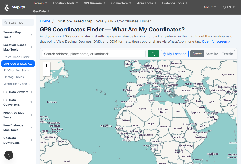
1Open the tool and choose how to get your point

On the toolbar, click "My Location" to use your device GPS, or simply click anywhere on the map to select that exact point instead — no permission needed for the second option.
Open the tool and choose how to get your point
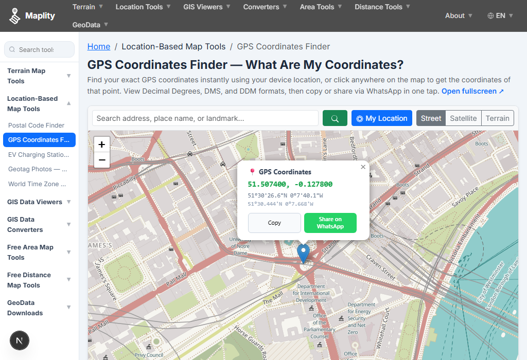
2Allow location access (if using My Location)

Your browser shows a permission prompt the first time. Allow it, and the map automatically pans and zooms to your current position with a marker placed exactly on it.
Allow location access (if using My Location)
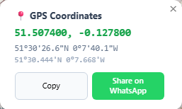
3Read the coordinates in the popup

A popup opens above the marker showing your position in three formats at once: Decimal Degrees (large, primary), DMS, and DDM — everything you need for any mapping system or GPS device.
Read the coordinates in the popup
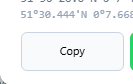
4Copy the coordinates with one click

Click "Copy" in the popup (or in the bottom info bar) to copy the Decimal Degrees value straight to your clipboard, ready to paste into Google Maps, a spreadsheet, or any other app.
Copy the coordinates with one click
5Share your location on WhatsApp

Click "Share on WhatsApp" in the popup. It opens WhatsApp with a pre-filled message containing your coordinates in Decimal Degrees and DMS, plus a direct Google Maps link — ready to send to anyone in seconds.

Share your location on WhatsApp
6Search a place instead, or switch to fullscreen

Prefer to find coordinates for a named place? Type it into the search box. For a larger working view, open the fullscreen version using the link below the map.

Search a place instead, or switch to fullscreen

6 Real-World Use Cases

Emergency & Roadside Situations: Share your exact position with emergency services, a breakdown recovery service, or a taxi driver when you are somewhere with no clear street address — a trailhead, a rural road, or open countryside.
Land Surveying & Fieldwork: Record a precise GPS reference point for a site inspection, boundary marker, or utility asset, then paste the coordinates directly into a field report or GIS dataset.
Real Estate & Rural Land Sales: Pin the exact coordinates of a plot corner, a rural property, or an off-grid parcel that has no formal address, so buyers can locate it precisely before visiting.
Delivery & Logistics: Send an exact pin to a delivery driver via WhatsApp when the destination address is incomplete, informal, or doesn't exist in a mapping database.
Outdoor Recreation: Share a favourite camping spot, fishing location, or trailhead with friends via WhatsApp so they can navigate straight to it with a single tap.
GIS & Data Entry: Quickly capture a reference coordinate to paste into a spreadsheet, database, or GIS project without opening a full desktop mapping application.

10 Frequently Asked Questions

Q: What coordinate format does this tool share on WhatsApp?
A: The tool shares your location in Decimal Degrees (DD) — for example 51.507400, -0.127800 — because it is the format almost every mapping platform, GPS device, and API accepts directly, including Google Maps, Apple Maps, and What3Words lookups. The share message also includes the DMS format and a ready-to-open Google Maps link for convenience.
Q: What's the difference between Decimal Degrees, DMS, and DDM?
A: Decimal Degrees (DD) expresses a coordinate as a single decimal number, e.g. 51.507400. Degrees Minutes Seconds (DMS) splits it into degrees, minutes, and seconds, e.g. 51°30'26.6"N — the traditional format used on paper charts and in surveying. Degrees Decimal Minutes (DDM) is a middle ground, e.g. 51°30.443'N, common in marine and aviation GPS units. All three describe the exact same point on Earth; they are just different ways of writing the same number.
Q: How accurate is "My Location" on this tool?
A: Accuracy depends on your device, not the tool. A phone with GPS enabled outdoors typically returns a position accurate to within 3–15 metres. A laptop without GPS hardware falls back to Wi-Fi or IP-based positioning, which can be accurate to a few hundred metres to a few kilometres. For survey-grade or high-stakes use, always cross-check against a dedicated GPS receiver.
Q: Does the tool work without giving location permission?
A: Yes. If you do not want to share your device location, simply click any point on the map instead — the tool reads the coordinates of the clicked point without needing any browser permission at all.
Q: Why does my browser ask for permission before finding my location?
A: Browsers require explicit permission before any website can access the Geolocation API, since your position is sensitive personal data. This tool only requests your location when you click "My Location" — it never tracks you in the background, and nothing is requested until you take that action.
Q: Will these coordinates work directly in Google Maps or Apple Maps?
A: Yes. Paste the Decimal Degrees value (e.g. 51.507400, -0.127800) directly into the Google Maps or Apple Maps search bar and it will jump straight to that point. The WhatsApp share message also includes a pre-built Google Maps link that opens the exact location with one tap.
Q: What coordinate reference system (datum) does this tool use?
A: All coordinates are in WGS84 (World Geodetic System 1984), the global standard datum used by GPS satellites, Google Maps, OpenStreetMap, and virtually every consumer mapping platform. If you need to convert to a local or historic datum (such as OSGB36 in the UK), a dedicated GIS tool like QGIS is required.
Q: Can I use this tool on my phone?
A: Yes, the tool is fully responsive and works in any modern mobile browser. On a phone, "My Location" typically returns a more accurate GPS fix than on a desktop computer, since phones have dedicated GPS hardware.
Q: Is my location data stored on a server?
A: No. Your device requests its position directly from the browser's built-in Geolocation API, and the coordinates are displayed and shared entirely in your own browser. Maplity does not log, store, or transmit your location to any server.
Q: Can I find the coordinates of a place by searching its name instead of clicking the map?
A: Yes — type an address, city, landmark, or place name into the search box and press Enter. The map zooms to that location and drops a marker showing its coordinates in all three formats, exactly as if you had clicked it directly.

Open Source & Credits

  • Map library: Leaflet — open-source interactive maps
  • Geocoding: Nominatim / OpenStreetMap — address search
  • Positioning: your browser's built-in Geolocation API — coordinates never pass through a Maplity server
  • Map tiles: CARTO Light, OpenStreetMap, Esri (satellite/terrain)
GPS Coordinates Finder — What Are My Coordinates? Free Map Tool | Maplity